

Weitlahnerkopf summit from hiking parking lot Mühlau
Between Kampenwand and Geigelstein in Chiemgau in Upper Bavaria lies the Weitlahnerkopf (1,516 m) - a quiet peak compared to its well-known neighbours

distance
duration
highest point
meters upwards
meters downwards
Summit hike Refreshment options: Haidenholzalm (*); Vordere Dalsenalm (Huber-Kaser) (*) Haidenholzalm (*); Vordere Dalsenalm (Huber-Kaser) (*) (*) Typical alpine snack, coffee and cake during the alpine grazing season (please note opening times) Achental hiking badge Checkpoints: Vordere Dalsenalm; Haidenholzalm; Blasialm Special features: Quiet Chiemgau mountain peak; in early summer a beautiful carpet of flowers around the summit cross; marmots on the Hintere DalsenalmDescription: From the Mühlau hiking car park, take the forest path to the Hintere Dalsenalmen. From here, a signposted path branches off to the left in the direction of Weitlahnerkopf, which you should follow. Over the so-called Dalsensattel, after a few switchbacks, you reach the somewhat steep Kaminsteig to the Weitlahner. The path leads over the slopes to the Rossalm down to the Haidenholzalm, which invites hikers to stop for refreshments. The route back to Mühlau goes over the Steigstatt past the Blasialm and over the forest path to the Schlechinger Au and over the Mühlbergweg to the starting point.
 https://www.achental.com/en/storage/sites/10/2024/11/CfTf5cT4owS1Qp6LQDSTH78DEdKxVbfAX4JlD5DH-scaled.jpg
1707
2560
admin
https://www.achental.com/wp-content/uploads/2022/07/achental-logo-weiss-horizontal-RGB@2x.png
admin2024-11-04 10:56:402024-11-11 12:03:39Kampenwand summit via Piesenhausener Hochalm
https://www.achental.com/en/storage/sites/10/2024/11/CfTf5cT4owS1Qp6LQDSTH78DEdKxVbfAX4JlD5DH-scaled.jpg
1707
2560
admin
https://www.achental.com/wp-content/uploads/2022/07/achental-logo-weiss-horizontal-RGB@2x.png
admin2024-11-04 10:56:402024-11-11 12:03:39Kampenwand summit via Piesenhausener Hochalm https://www.achental.com/en/storage/sites/10/2024/11/uUnvDBePtrwGxcf8hbdGtCLbYq6bvqClVXDV3WE1-scaled.jpg
1707
2560
admin
https://www.achental.com/wp-content/uploads/2022/07/achental-logo-weiss-horizontal-RGB@2x.png
admin2024-10-28 11:30:412024-11-11 12:23:43Via Rechenbergalm to Jochbergalm
https://www.achental.com/en/storage/sites/10/2024/11/uUnvDBePtrwGxcf8hbdGtCLbYq6bvqClVXDV3WE1-scaled.jpg
1707
2560
admin
https://www.achental.com/wp-content/uploads/2022/07/achental-logo-weiss-horizontal-RGB@2x.png
admin2024-10-28 11:30:412024-11-11 12:23:43Via Rechenbergalm to Jochbergalm https://www.achental.com/en/storage/sites/10/2024/11/55164_DSC00027.jpg
1536
2048
admin
https://www.achental.com/wp-content/uploads/2022/07/achental-logo-weiss-horizontal-RGB@2x.png
admin2024-10-28 11:30:382024-11-11 12:22:38via Aßberg- and Stoibenmöseralm to Lake Taubensee
https://www.achental.com/en/storage/sites/10/2024/11/55164_DSC00027.jpg
1536
2048
admin
https://www.achental.com/wp-content/uploads/2022/07/achental-logo-weiss-horizontal-RGB@2x.png
admin2024-10-28 11:30:382024-11-11 12:22:38via Aßberg- and Stoibenmöseralm to Lake Taubensee https://www.achental.com/en/storage/sites/10/2024/11/Mzbvkr2CVhjK2elYUvMyzVhNyuNFaMI5cyF0se8D-scaled.jpg
1920
2560
admin
https://www.achental.com/wp-content/uploads/2022/07/achental-logo-weiss-horizontal-RGB@2x.png
admin2024-10-28 11:30:282024-11-11 12:18:43Lake Taubensee
https://www.achental.com/en/storage/sites/10/2024/11/Mzbvkr2CVhjK2elYUvMyzVhNyuNFaMI5cyF0se8D-scaled.jpg
1920
2560
admin
https://www.achental.com/wp-content/uploads/2022/07/achental-logo-weiss-horizontal-RGB@2x.png
admin2024-10-28 11:30:282024-11-11 12:18:43Lake Taubensee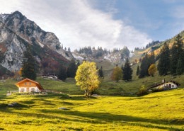 https://www.achental.com/en/storage/sites/10/2024/11/aJWXj57v5rjy8wtiz7Vo1tQ3SLyFL0XimBACYkyS.jpg
848
1584
admin
https://www.achental.com/wp-content/uploads/2022/07/achental-logo-weiss-horizontal-RGB@2x.png
admin2024-10-28 11:30:152024-11-11 11:58:28Gams Rundweg
https://www.achental.com/en/storage/sites/10/2024/11/aJWXj57v5rjy8wtiz7Vo1tQ3SLyFL0XimBACYkyS.jpg
848
1584
admin
https://www.achental.com/wp-content/uploads/2022/07/achental-logo-weiss-horizontal-RGB@2x.png
admin2024-10-28 11:30:152024-11-11 11:58:28Gams Rundweg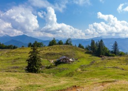 https://www.achental.com/en/storage/sites/10/2024/11/Q8hrtcs0fpd23OG0IqfL4csJScbu4hFENdIsS4vB-scaled.jpeg
1707
2560
admin
https://www.achental.com/wp-content/uploads/2022/07/achental-logo-weiss-horizontal-RGB@2x.png
admin2024-10-28 11:30:102024-11-11 12:19:38Lake Taubensee Loop – Festsaal
https://www.achental.com/en/storage/sites/10/2024/11/Q8hrtcs0fpd23OG0IqfL4csJScbu4hFENdIsS4vB-scaled.jpeg
1707
2560
admin
https://www.achental.com/wp-content/uploads/2022/07/achental-logo-weiss-horizontal-RGB@2x.png
admin2024-10-28 11:30:102024-11-11 12:19:38Lake Taubensee Loop – Festsaal https://www.achental.com/en/storage/sites/10/2024/11/AlPF6RbIW1U1m98MB2QDZ3tKDNqVU6mKoZy6jruc-scaled.jpeg
1707
2560
admin
https://www.achental.com/wp-content/uploads/2022/07/achental-logo-weiss-horizontal-RGB@2x.png
admin2024-10-28 11:30:082024-11-11 12:17:54Streichen-Luftbodensteig-Wetterkreuz-Runde mit Wanderbus
https://www.achental.com/en/storage/sites/10/2024/11/AlPF6RbIW1U1m98MB2QDZ3tKDNqVU6mKoZy6jruc-scaled.jpeg
1707
2560
admin
https://www.achental.com/wp-content/uploads/2022/07/achental-logo-weiss-horizontal-RGB@2x.png
admin2024-10-28 11:30:082024-11-11 12:17:54Streichen-Luftbodensteig-Wetterkreuz-Runde mit Wanderbus https://www.achental.com/en/storage/sites/10/2024/11/KKX9UDoPV12aMw9wvyEJ367aiX6VkZbBz3SUeNbQ-scaled.jpg
1707
2560
admin
https://www.achental.com/wp-content/uploads/2022/07/achental-logo-weiss-horizontal-RGB@2x.png
admin2024-10-25 15:48:502024-11-11 12:23:28Über die Chiemhauseralm zur Streichenkirche
https://www.achental.com/en/storage/sites/10/2024/11/KKX9UDoPV12aMw9wvyEJ367aiX6VkZbBz3SUeNbQ-scaled.jpg
1707
2560
admin
https://www.achental.com/wp-content/uploads/2022/07/achental-logo-weiss-horizontal-RGB@2x.png
admin2024-10-25 15:48:502024-11-11 12:23:28Über die Chiemhauseralm zur Streichenkirche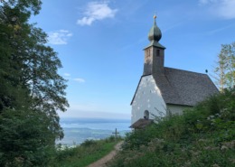 https://www.achental.com/en/storage/sites/10/2024/11/YuBEWcTAG6kGb1MRqk1X3HwCccv4yWrf9k7cmFvy-scaled.jpg
1920
2560
admin
https://www.achental.com/wp-content/uploads/2022/07/achental-logo-weiss-horizontal-RGB@2x.png
admin2024-10-25 15:48:312024-11-11 12:12:22Circular trail Hochgern-Staudacheralm-Schnappenkirche
https://www.achental.com/en/storage/sites/10/2024/11/YuBEWcTAG6kGb1MRqk1X3HwCccv4yWrf9k7cmFvy-scaled.jpg
1920
2560
admin
https://www.achental.com/wp-content/uploads/2022/07/achental-logo-weiss-horizontal-RGB@2x.png
admin2024-10-25 15:48:312024-11-11 12:12:22Circular trail Hochgern-Staudacheralm-Schnappenkirche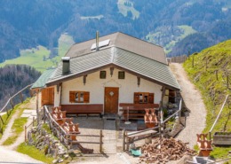 https://www.achental.com/en/storage/sites/10/2024/11/ajhHr9nlIDHI0wNwKZd4xkt3KVPqpTfTSduK9y9c-scaled.jpg
1707
2560
admin
https://www.achental.com/wp-content/uploads/2022/07/achental-logo-weiss-horizontal-RGB@2x.png
admin2024-10-25 15:48:082024-11-11 11:49:51Almenwanderung zum Jochberg
https://www.achental.com/en/storage/sites/10/2024/11/ajhHr9nlIDHI0wNwKZd4xkt3KVPqpTfTSduK9y9c-scaled.jpg
1707
2560
admin
https://www.achental.com/wp-content/uploads/2022/07/achental-logo-weiss-horizontal-RGB@2x.png
admin2024-10-25 15:48:082024-11-11 11:49:51Almenwanderung zum Jochberg https://www.achental.com/en/storage/sites/10/2024/11/89257_k-P1060725.jpg
480
640
admin
https://www.achental.com/wp-content/uploads/2022/07/achental-logo-weiss-horizontal-RGB@2x.png
admin2024-10-25 15:47:592024-11-11 12:21:07Taubensee-High Alpine Pastures-Circular Tour
https://www.achental.com/en/storage/sites/10/2024/11/89257_k-P1060725.jpg
480
640
admin
https://www.achental.com/wp-content/uploads/2022/07/achental-logo-weiss-horizontal-RGB@2x.png
admin2024-10-25 15:47:592024-11-11 12:21:07Taubensee-High Alpine Pastures-Circular Tour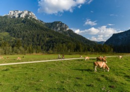 https://www.achental.com/en/storage/sites/10/2024/11/v2lStkdnqe1Ztz8Iavp0ZiJSiEXc6UAptynuQuFF-scaled.jpeg
1709
2560
admin
https://www.achental.com/wp-content/uploads/2022/07/achental-logo-weiss-horizontal-RGB@2x.png
admin2024-10-25 15:47:262024-11-11 12:25:44From Unterwössen via Jochbergalm, Röthelmoos to Weitsee
https://www.achental.com/en/storage/sites/10/2024/11/v2lStkdnqe1Ztz8Iavp0ZiJSiEXc6UAptynuQuFF-scaled.jpeg
1709
2560
admin
https://www.achental.com/wp-content/uploads/2022/07/achental-logo-weiss-horizontal-RGB@2x.png
admin2024-10-25 15:47:262024-11-11 12:25:44From Unterwössen via Jochbergalm, Röthelmoos to Weitsee https://www.achental.com/en/storage/sites/10/2024/11/51253_DSC00673_1920x1278.jpg
1278
1920
admin
https://www.achental.com/wp-content/uploads/2022/07/achental-logo-weiss-horizontal-RGB@2x.png
admin2024-10-25 15:47:182024-11-11 12:10:38Circular tour via Rachl-Alm and Hefter-Alm
https://www.achental.com/en/storage/sites/10/2024/11/51253_DSC00673_1920x1278.jpg
1278
1920
admin
https://www.achental.com/wp-content/uploads/2022/07/achental-logo-weiss-horizontal-RGB@2x.png
admin2024-10-25 15:47:182024-11-11 12:10:38Circular tour via Rachl-Alm and Hefter-Alm https://www.achental.com/en/storage/sites/10/2024/11/57836_Charakter_Blasialm_Rundweg.jpg
533
977
admin
https://www.achental.com/wp-content/uploads/2022/07/achental-logo-weiss-horizontal-RGB@2x.png
admin2024-10-25 15:47:172024-11-11 11:55:14Blasialm-Rundweg
https://www.achental.com/en/storage/sites/10/2024/11/57836_Charakter_Blasialm_Rundweg.jpg
533
977
admin
https://www.achental.com/wp-content/uploads/2022/07/achental-logo-weiss-horizontal-RGB@2x.png
admin2024-10-25 15:47:172024-11-11 11:55:14Blasialm-Rundweg https://www.achental.com/en/storage/sites/10/2024/11/57837_Charakter_Samer_Rundweg.jpg
447
977
admin
https://www.achental.com/wp-content/uploads/2022/07/achental-logo-weiss-horizontal-RGB@2x.png
admin2024-10-25 15:45:042024-11-11 12:13:53Schmuggler/Samer Trail – circular tour
https://www.achental.com/en/storage/sites/10/2024/11/57837_Charakter_Samer_Rundweg.jpg
447
977
admin
https://www.achental.com/wp-content/uploads/2022/07/achental-logo-weiss-horizontal-RGB@2x.png
admin2024-10-25 15:45:042024-11-11 12:13:53Schmuggler/Samer Trail – circular tour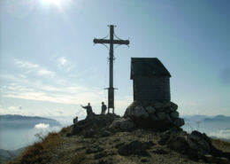 https://www.achental.com/en/storage/sites/10/2024/11/57431_PICT2717.jpg
1200
1600
admin
https://www.achental.com/wp-content/uploads/2022/07/achental-logo-weiss-horizontal-RGB@2x.png
admin2024-10-25 15:44:262024-11-11 11:58:36Geigelstein – summit hike
https://www.achental.com/en/storage/sites/10/2024/11/57431_PICT2717.jpg
1200
1600
admin
https://www.achental.com/wp-content/uploads/2022/07/achental-logo-weiss-horizontal-RGB@2x.png
admin2024-10-25 15:44:262024-11-11 11:58:36Geigelstein – summit hike https://www.achental.com/en/storage/sites/10/2024/11/74094_donauer_alm_2.jpg
695
1024
admin
https://www.achental.com/wp-content/uploads/2022/07/achental-logo-weiss-horizontal-RGB@2x.png
admin2024-10-25 15:44:152024-11-11 11:55:46Chiemhauser Alm
https://www.achental.com/en/storage/sites/10/2024/11/74094_donauer_alm_2.jpg
695
1024
admin
https://www.achental.com/wp-content/uploads/2022/07/achental-logo-weiss-horizontal-RGB@2x.png
admin2024-10-25 15:44:152024-11-11 11:55:46Chiemhauser Alm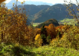 https://www.achental.com/en/storage/sites/10/2024/11/46066_DSC00056.jpg
1200
1600
admin
https://www.achental.com/wp-content/uploads/2022/07/achental-logo-weiss-horizontal-RGB@2x.png
admin2024-10-25 15:44:042024-11-11 12:09:17Rechenbergalm via Feldlahnalm – alpine pasture hike
https://www.achental.com/en/storage/sites/10/2024/11/46066_DSC00056.jpg
1200
1600
admin
https://www.achental.com/wp-content/uploads/2022/07/achental-logo-weiss-horizontal-RGB@2x.png
admin2024-10-25 15:44:042024-11-11 12:09:17Rechenbergalm via Feldlahnalm – alpine pasture hike https://www.achental.com/en/storage/sites/10/2024/11/88896_Jochberg-Almen.jpg
777
1371
admin
https://www.achental.com/wp-content/uploads/2022/07/achental-logo-weiss-horizontal-RGB@2x.png
admin2024-10-25 15:43:262024-11-11 12:26:08Hike to Jochberg-Almen
https://www.achental.com/en/storage/sites/10/2024/11/88896_Jochberg-Almen.jpg
777
1371
admin
https://www.achental.com/wp-content/uploads/2022/07/achental-logo-weiss-horizontal-RGB@2x.png
admin2024-10-25 15:43:262024-11-11 12:26:08Hike to Jochberg-Almen https://www.achental.com/en/storage/sites/10/2024/11/QuD95Vu6VVdOguddHzlLIFhPM8Rcfk4vwTK6v2ny-scaled.jpeg
1723
2560
admin
https://www.achental.com/wp-content/uploads/2022/07/achental-logo-weiss-horizontal-RGB@2x.png
admin2024-10-25 15:43:242024-11-11 12:25:13From Streichenkirche church via Kroatensteig trail to lake Taubensee and Reit im Winkl
https://www.achental.com/en/storage/sites/10/2024/11/QuD95Vu6VVdOguddHzlLIFhPM8Rcfk4vwTK6v2ny-scaled.jpeg
1723
2560
admin
https://www.achental.com/wp-content/uploads/2022/07/achental-logo-weiss-horizontal-RGB@2x.png
admin2024-10-25 15:43:242024-11-11 12:25:13From Streichenkirche church via Kroatensteig trail to lake Taubensee and Reit im Winkl

 Circular tour Vorderalm – Brachtalm – Staudacher Alm