Lake Taubensee via Luftboden- and Kroatensteig
Demanding circular route via the Luftbodensteig to the Taubensee and back via the Kroatensteig.

Demanding circular route via the Luftbodensteig to the Taubensee and back via the Kroatensteig.
distance
duration
highest point
meters upwards
meters downwards
Difficulty
difficult
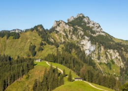
Mountain hikeRefreshment options: Taubenseehütte (*); Chiemhauser Alm (*); Stoibenmöseralm (*) (*) typical alpine snack, coffee and cake during the alpine grazing season (please note opening times)Achental hiking badge checkpoints: Hinterwössen circular route; Schwaigeralm; Taubensee; Chiemhauser AlmSpecial features: beautiful, refreshing mountain lake with swimming facilities; rare crabs in the lake; bizarre rock holes on the lake shoreTip: to cool off, take your bathing suit and jump into the TaubenseeDescription: Taubensee car park-Hinterwössen – Schlierbach – Luftbodensteig – Luftbodensattel – Taubensee – Taubensee-Hütte – Kroatensteig – Chiemhauseralm – Schlierbach – Taubensee car park-Hinterwössen The tour starts at the hiking car park in Hinterwössen. Here we follow path no. 9 along the Schlierbach. Shortly before the Schwaigeralm, the path winds up to the left to the Luftboden saddle, from where you can quickly reach the Taubensee. The Taubensee is located in a small basin. The border between Germany and Austria runs through it. From here, you can reach the Taubensee hut, which is already on Austrian territory, in just a few minutes. From the Taubensee hut, you go back a little way and the Kroatensteig branches off at the former customs hut. Shortly before the Chiemhauseralm, you follow the forest path to the right and soon come back to the ascent path, which you now follow back to the car park. At the Taubensee hut, the view opens up to the Tyrolean mountains.
Einkehrmöglichkeit
Taubenseeparkplatz-Hinterwössen
 https://www.achental.com/en/storage/sites/10/2024/11/3cBMJGbVQjuArEHVWDZYZ3qcFakrOd8IToiuQfwm-scaled.jpg
1707
2560
admin
https://www.achental.com/wp-content/uploads/2022/07/achental-logo-weiss-horizontal-RGB@2x.png
admin2024-11-06 09:24:352024-11-11 12:09:02Piesenhausener Hochalm
 https://www.achental.com/en/storage/sites/10/2024/11/53357_DSC00015.jpg
1536
2048
admin
https://www.achental.com/wp-content/uploads/2022/07/achental-logo-weiss-horizontal-RGB@2x.png
admin2024-10-28 11:30:442024-11-11 12:20:54Lake Taubensee via Luftboden- and Kroatensteig
 https://www.achental.com/en/storage/sites/10/2024/11/54048_DSC00077.jpg
1536
2048
admin
https://www.achental.com/wp-content/uploads/2022/07/achental-logo-weiss-horizontal-RGB@2x.png
admin2024-10-28 11:30:432024-11-11 11:56:05Chiemseeblick und Kruchenhausener Runde
 https://www.achental.com/en/storage/sites/10/2024/11/CDTMsg4Hb2DS5BtnZcYGmBuAfCyveA4EbBoRaaeb-scaled.jpg
1840
2560
admin
https://www.achental.com/wp-content/uploads/2022/07/achental-logo-weiss-horizontal-RGB@2x.png
admin2024-10-28 11:30:232024-11-11 12:00:51Valley circular trail
 https://www.achental.com/en/storage/sites/10/2024/11/VVT8YD8z5ZEAzoiXkshUne9HdSbxdwHaAkTvV3bW-scaled.jpg
1919
2560
admin
https://www.achental.com/wp-content/uploads/2022/07/achental-logo-weiss-horizontal-RGB@2x.png
admin2024-10-28 11:30:222024-11-11 12:00:15Grießelberg-Rundweg
 https://www.achental.com/en/storage/sites/10/2024/11/9VruSXPV8ePSxZlnGpViGMZqYnWT2WmVj6N21gVK.webp
768
576
admin
https://www.achental.com/wp-content/uploads/2022/07/achental-logo-weiss-horizontal-RGB@2x.png
admin2024-10-28 11:30:192024-11-11 11:57:18Feldlahnalm tour
 https://www.achental.com/en/storage/sites/10/2024/11/dnnXUqmOoT9qsZJ2w9KjLhaU9rm1fN1Pzba35MkA.jpg
1500
1000
admin
https://www.achental.com/wp-content/uploads/2022/07/achental-logo-weiss-horizontal-RGB@2x.png
admin2024-10-28 11:30:172024-11-11 12:05:36Kneipp circular tour
 https://www.achental.com/en/storage/sites/10/2024/11/89256_DSC00025.jpg
1536
2048
admin
https://www.achental.com/wp-content/uploads/2022/07/achental-logo-weiss-horizontal-RGB@2x.png
admin2024-10-25 15:47:522024-11-11 12:11:00Circular hike Hinterwössen
 https://www.achental.com/en/storage/sites/10/2024/11/sI0JyHhoSTI8r8TCYiee1ydZojiMieRrirnifIF6-scaled.jpg
1707
2560
admin
https://www.achental.com/wp-content/uploads/2022/07/achental-logo-weiss-horizontal-RGB@2x.png
admin2024-10-25 15:47:352024-11-11 11:52:40Auf historischen Pfaden
 https://www.achental.com/en/storage/sites/10/2024/11/88876_Logo_Bergwalderlebnisweg_Specht.jpg
416
500
admin
https://www.achental.com/wp-content/uploads/2022/07/achental-logo-weiss-horizontal-RGB@2x.png
admin2024-10-25 15:43:432024-11-11 11:53:03Bergwalderlebnisweg Staffen
 https://www.achental.com/en/storage/sites/10/2024/11/88895_Staudacher_Alm.jpg
353
621
admin
https://www.achental.com/wp-content/uploads/2022/07/achental-logo-weiss-horizontal-RGB@2x.png
admin2024-10-25 15:43:292024-11-11 12:26:16Hike to Staudacher Alm
 https://www.achental.com/en/storage/sites/10/2024/11/51266_Bank_mit_Aussicht_-_Minaruh-scaled.jpg
1714
2560
admin
https://www.achental.com/wp-content/uploads/2022/07/achental-logo-weiss-horizontal-RGB@2x.png
admin2024-10-01 17:50:352024-11-11 11:58:07River and moor hike through the Achental
 https://www.achental.com/en/storage/sites/10/2024/11/Te2tS4q2ZNk5iEXddzTbag4xoStiEYcopEfwl9o0-scaled.jpg
1707
2560
admin
https://www.achental.com/wp-content/uploads/2022/07/achental-logo-weiss-horizontal-RGB@2x.png
admin2024-10-01 17:50:342024-11-11 11:51:38Almwanderung zur Rechenberg-Alm
 https://www.achental.com/en/storage/sites/10/2024/11/EH3CPTXurhRqZOwEUt1orWVrTFXkfhD2LU1KWGzY-scaled.jpg
1708
2560
admin
https://www.achental.com/wp-content/uploads/2022/07/achental-logo-weiss-horizontal-RGB@2x.png
admin2024-10-01 17:50:332024-11-11 12:11:39Circular tour to Marquartstein castle and river Tiroler Ache dam
 https://www.achental.com/en/storage/sites/10/2024/11/N2bNvLXAlAVqBVUmhM8WBwzY1qUKdpLbN0RQxYkn-scaled.jpg
1707
2560
admin
https://www.achental.com/wp-content/uploads/2022/07/achental-logo-weiss-horizontal-RGB@2x.png
admin2024-10-01 17:50:322024-11-11 12:12:18Circular trail Zeppelinhöhe
 https://www.achental.com/en/storage/sites/10/2024/11/eF5RWwpHLyZRBXIEDfQQZANZgDDIFpK9upEuLTMb-scaled.jpg
1919
2560
admin
https://www.achental.com/wp-content/uploads/2022/07/achental-logo-weiss-horizontal-RGB@2x.png
admin2024-10-01 17:50:312024-11-11 12:10:05Around Marquartstein castle
 https://www.achental.com/wp-content/uploads/2022/07/achental-logo-weiss-horizontal-RGB@2x.png
0
0
admin
https://www.achental.com/wp-content/uploads/2022/07/achental-logo-weiss-horizontal-RGB@2x.png
admin2024-10-01 17:50:312024-11-11 12:11:13Rundweg Schnappenwinkl – Staudach
https://www.achental.com/wp-content/uploads/2022/07/achental-logo-weiss-horizontal-RGB@2x.png
0
0
admin
https://www.achental.com/wp-content/uploads/2022/07/achental-logo-weiss-horizontal-RGB@2x.png
admin2024-10-01 17:50:312024-11-11 12:11:13Rundweg Schnappenwinkl – Staudach https://www.achental.com/en/storage/sites/10/2024/11/VhHN4nXmW8xKONAeuQqQjojDTSMjF3WQttzza5NH-scaled.jpg
1707
2560
admin
https://www.achental.com/wp-content/uploads/2022/07/achental-logo-weiss-horizontal-RGB@2x.png
admin2024-10-01 17:50:272024-11-11 12:15:16Schnappenkirche
 https://www.achental.com/en/storage/sites/10/2024/11/65WXYhJdPWmJTz4k5TUHiKCTixL2EgZmb2hAPpa1-scaled.jpg
1919
2560
admin
https://www.achental.com/wp-content/uploads/2022/07/achental-logo-weiss-horizontal-RGB@2x.png
admin2024-10-01 17:50:272024-11-11 12:10:47Circular tour via Minaruh and Streunthal
 https://www.achental.com/en/storage/sites/10/2024/11/BB6c390WBwrPa41LKQngrCwHVl0PRm8DcXUWGi0u-scaled.jpg
1707
2560
admin
https://www.achental.com/wp-content/uploads/2022/07/achental-logo-weiss-horizontal-RGB@2x.png
admin2024-10-01 17:50:272024-11-11 12:24:38To Unterwössen along Tiroler Ache and Richard-Strauss Höhenweg )
 Kampenwand summit via Piesenhausener Hochalm
 Achental - Chiemsee-Chiemgau holiday region
We firmly believe that the internet should be available and accessible to anyone, and are committed to providing a website that is accessible to the widest possible audience, regardless of circumstance and ability.
To fulfill this, we aim to adhere as strictly as possible to the World Wide Web Consortium’s (W3C) Web Content Accessibility Guidelines 2.1 (WCAG 2.1) at the AA level. These guidelines explain how to make web content accessible to people with a wide array of disabilities. Complying with those guidelines helps us ensure that the website is accessible to all people: blind people, people with motor impairments, visual impairment, cognitive disabilities, and more.
This website utilizes various technologies that are meant to make it as accessible as possible at all times. We utilize an accessibility interface that allows persons with specific disabilities to adjust the website’s UI (user interface) and design it to their personal needs.
Additionally, the website utilizes an AI-based application that runs in the background and optimizes its accessibility level constantly. This application remediates the website’s HTML, adapts Its functionality and behavior for screen-readers used by the blind users, and for keyboard functions used by individuals with motor impairments.
If you’ve found a malfunction or have ideas for improvement, we’ll be happy to hear from you. You can reach out to the website’s operators by using the following email
Our website implements the ARIA attributes (Accessible Rich Internet Applications) technique, alongside various different behavioral changes, to ensure blind users visiting with screen-readers are able to read, comprehend, and enjoy the website’s functions. As soon as a user with a screen-reader enters your site, they immediately receive a prompt to enter the Screen-Reader Profile so they can browse and operate your site effectively. Here’s how our website covers some of the most important screen-reader requirements, alongside console screenshots of code examples:
Screen-reader optimization: we run a background process that learns the website’s components from top to bottom, to ensure ongoing compliance even when updating the website. In this process, we provide screen-readers with meaningful data using the ARIA set of attributes. For example, we provide accurate form labels; descriptions for actionable icons (social media icons, search icons, cart icons, etc.); validation guidance for form inputs; element roles such as buttons, menus, modal dialogues (popups), and others. Additionally, the background process scans all the website’s images and provides an accurate and meaningful image-object-recognition-based description as an ALT (alternate text) tag for images that are not described. It will also extract texts that are embedded within the image, using an OCR (optical character recognition) technology. To turn on screen-reader adjustments at any time, users need only to press the Alt+1 keyboard combination. Screen-reader users also get automatic announcements to turn the Screen-reader mode on as soon as they enter the website.
These adjustments are compatible with all popular screen readers, including JAWS and NVDA.
Keyboard navigation optimization: The background process also adjusts the website’s HTML, and adds various behaviors using JavaScript code to make the website operable by the keyboard. This includes the ability to navigate the website using the Tab and Shift+Tab keys, operate dropdowns with the arrow keys, close them with Esc, trigger buttons and links using the Enter key, navigate between radio and checkbox elements using the arrow keys, and fill them in with the Spacebar or Enter key.Additionally, keyboard users will find quick-navigation and content-skip menus, available at any time by clicking Alt+1, or as the first elements of the site while navigating with the keyboard. The background process also handles triggered popups by moving the keyboard focus towards them as soon as they appear, and not allow the focus drift outside it.
Users can also use shortcuts such as “M” (menus), “H” (headings), “F” (forms), “B” (buttons), and “G” (graphics) to jump to specific elements.
We aim to support the widest array of browsers and assistive technologies as possible, so our users can choose the best fitting tools for them, with as few limitations as possible. Therefore, we have worked very hard to be able to support all major systems that comprise over 95% of the user market share including Google Chrome, Mozilla Firefox, Apple Safari, Opera and Microsoft Edge, JAWS and NVDA (screen readers).
Despite our very best efforts to allow anybody to adjust the website to their needs. There may still be pages or sections that are not fully accessible, are in the process of becoming accessible, or are lacking an adequate technological solution to make them accessible. Still, we are continually improving our accessibility, adding, updating and improving its options and features, and developing and adopting new technologies. All this is meant to reach the optimal level of accessibility, following technological advancements. For any assistance, please reach out to
