

Circular trail Zeppelinhöhe
Zeppelinhöhe circular route (from the Hochplattenbahn valley station)

distance
duration
highest point
meters upwards
meters downwards
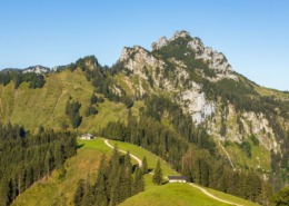
The hike to Zeppelinhöhe begins at the Hochplattenbahn car park. After about 1 km, the path to Hochplatte branches off to the left, but we continue straight on in the direction of Rachl-Alm and cross the Tennbodenbach. The path initially leads us mostly through the forest and crosses the Hochplattenbahn route. Where we emerge from the forest, a sign points us to the right in the direction of Zeppelinhöhe. The path winds its way through the forest down to the so-called upper Torgraben. We cross a mountain stream that does not usually carry a lot of water and in a few minutes we reach Zeppelinhöhe, where a memorial stone commemorates the inventor of the Zeppelin. A bench invites you to linger and the view opens up in front of us to Grassau, Marquartstein, the Achental, Kendlmühlfilzen and as far as Lake Chiemsee. We walk back the short distance and then keep to the right. After a few meters, the path winds its way down to the Torgraben in the direction of the Hochplattenbahn (valley station) and we follow the signs to the valley station, which we reach by walking slightly uphill past the fairytale park. Refreshment options: Rachl Alm (small detour), Café Jägerwinkl (near the fairytale park)
 https://www.achental.com/en/storage/sites/10/2024/11/3cBMJGbVQjuArEHVWDZYZ3qcFakrOd8IToiuQfwm-scaled.jpg
1707
2560
admin
https://www.achental.com/wp-content/uploads/2022/07/achental-logo-weiss-horizontal-RGB@2x.png
admin2024-11-06 09:24:352024-11-11 12:09:02Piesenhausener Hochalm
https://www.achental.com/en/storage/sites/10/2024/11/3cBMJGbVQjuArEHVWDZYZ3qcFakrOd8IToiuQfwm-scaled.jpg
1707
2560
admin
https://www.achental.com/wp-content/uploads/2022/07/achental-logo-weiss-horizontal-RGB@2x.png
admin2024-11-06 09:24:352024-11-11 12:09:02Piesenhausener Hochalm https://www.achental.com/en/storage/sites/10/2024/11/53357_DSC00015.jpg
1536
2048
admin
https://www.achental.com/wp-content/uploads/2022/07/achental-logo-weiss-horizontal-RGB@2x.png
admin2024-10-28 11:30:442024-11-11 12:20:54Lake Taubensee via Luftboden- and Kroatensteig
https://www.achental.com/en/storage/sites/10/2024/11/53357_DSC00015.jpg
1536
2048
admin
https://www.achental.com/wp-content/uploads/2022/07/achental-logo-weiss-horizontal-RGB@2x.png
admin2024-10-28 11:30:442024-11-11 12:20:54Lake Taubensee via Luftboden- and Kroatensteig https://www.achental.com/en/storage/sites/10/2024/11/54048_DSC00077.jpg
1536
2048
admin
https://www.achental.com/wp-content/uploads/2022/07/achental-logo-weiss-horizontal-RGB@2x.png
admin2024-10-28 11:30:432024-11-11 11:56:05Chiemseeblick und Kruchenhausener Runde
https://www.achental.com/en/storage/sites/10/2024/11/54048_DSC00077.jpg
1536
2048
admin
https://www.achental.com/wp-content/uploads/2022/07/achental-logo-weiss-horizontal-RGB@2x.png
admin2024-10-28 11:30:432024-11-11 11:56:05Chiemseeblick und Kruchenhausener Runde https://www.achental.com/en/storage/sites/10/2024/11/CDTMsg4Hb2DS5BtnZcYGmBuAfCyveA4EbBoRaaeb-scaled.jpg
1840
2560
admin
https://www.achental.com/wp-content/uploads/2022/07/achental-logo-weiss-horizontal-RGB@2x.png
admin2024-10-28 11:30:232024-11-11 12:00:51Valley circular trail
https://www.achental.com/en/storage/sites/10/2024/11/CDTMsg4Hb2DS5BtnZcYGmBuAfCyveA4EbBoRaaeb-scaled.jpg
1840
2560
admin
https://www.achental.com/wp-content/uploads/2022/07/achental-logo-weiss-horizontal-RGB@2x.png
admin2024-10-28 11:30:232024-11-11 12:00:51Valley circular trail https://www.achental.com/en/storage/sites/10/2024/11/VVT8YD8z5ZEAzoiXkshUne9HdSbxdwHaAkTvV3bW-scaled.jpg
1919
2560
admin
https://www.achental.com/wp-content/uploads/2022/07/achental-logo-weiss-horizontal-RGB@2x.png
admin2024-10-28 11:30:222024-11-11 12:00:15Grießelberg-Rundweg
https://www.achental.com/en/storage/sites/10/2024/11/VVT8YD8z5ZEAzoiXkshUne9HdSbxdwHaAkTvV3bW-scaled.jpg
1919
2560
admin
https://www.achental.com/wp-content/uploads/2022/07/achental-logo-weiss-horizontal-RGB@2x.png
admin2024-10-28 11:30:222024-11-11 12:00:15Grießelberg-Rundweg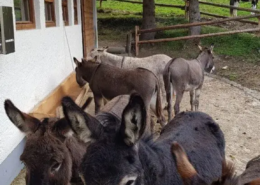 https://www.achental.com/en/storage/sites/10/2024/11/9VruSXPV8ePSxZlnGpViGMZqYnWT2WmVj6N21gVK.webp
768
576
admin
https://www.achental.com/wp-content/uploads/2022/07/achental-logo-weiss-horizontal-RGB@2x.png
admin2024-10-28 11:30:192024-11-11 11:57:18Feldlahnalm tour
https://www.achental.com/en/storage/sites/10/2024/11/9VruSXPV8ePSxZlnGpViGMZqYnWT2WmVj6N21gVK.webp
768
576
admin
https://www.achental.com/wp-content/uploads/2022/07/achental-logo-weiss-horizontal-RGB@2x.png
admin2024-10-28 11:30:192024-11-11 11:57:18Feldlahnalm tour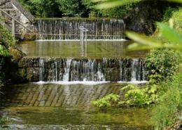 https://www.achental.com/en/storage/sites/10/2024/11/dnnXUqmOoT9qsZJ2w9KjLhaU9rm1fN1Pzba35MkA.jpg
1500
1000
admin
https://www.achental.com/wp-content/uploads/2022/07/achental-logo-weiss-horizontal-RGB@2x.png
admin2024-10-28 11:30:172024-11-11 12:05:36Kneipp circular tour
https://www.achental.com/en/storage/sites/10/2024/11/dnnXUqmOoT9qsZJ2w9KjLhaU9rm1fN1Pzba35MkA.jpg
1500
1000
admin
https://www.achental.com/wp-content/uploads/2022/07/achental-logo-weiss-horizontal-RGB@2x.png
admin2024-10-28 11:30:172024-11-11 12:05:36Kneipp circular tour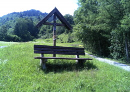 https://www.achental.com/en/storage/sites/10/2024/11/89256_DSC00025.jpg
1536
2048
admin
https://www.achental.com/wp-content/uploads/2022/07/achental-logo-weiss-horizontal-RGB@2x.png
admin2024-10-25 15:47:522024-11-11 12:11:00Circular hike Hinterwössen
https://www.achental.com/en/storage/sites/10/2024/11/89256_DSC00025.jpg
1536
2048
admin
https://www.achental.com/wp-content/uploads/2022/07/achental-logo-weiss-horizontal-RGB@2x.png
admin2024-10-25 15:47:522024-11-11 12:11:00Circular hike Hinterwössen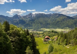 https://www.achental.com/en/storage/sites/10/2024/11/sI0JyHhoSTI8r8TCYiee1ydZojiMieRrirnifIF6-scaled.jpg
1707
2560
admin
https://www.achental.com/wp-content/uploads/2022/07/achental-logo-weiss-horizontal-RGB@2x.png
admin2024-10-25 15:47:352024-11-11 11:52:40Auf historischen Pfaden
https://www.achental.com/en/storage/sites/10/2024/11/sI0JyHhoSTI8r8TCYiee1ydZojiMieRrirnifIF6-scaled.jpg
1707
2560
admin
https://www.achental.com/wp-content/uploads/2022/07/achental-logo-weiss-horizontal-RGB@2x.png
admin2024-10-25 15:47:352024-11-11 11:52:40Auf historischen Pfaden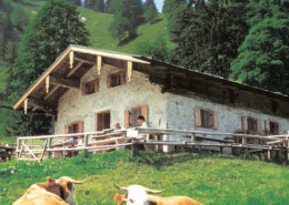 https://www.achental.com/en/storage/sites/10/2024/11/88895_Staudacher_Alm.jpg
353
621
admin
https://www.achental.com/wp-content/uploads/2022/07/achental-logo-weiss-horizontal-RGB@2x.png
admin2024-10-25 15:43:292024-11-11 12:26:16Hike to Staudacher Alm
https://www.achental.com/en/storage/sites/10/2024/11/88895_Staudacher_Alm.jpg
353
621
admin
https://www.achental.com/wp-content/uploads/2022/07/achental-logo-weiss-horizontal-RGB@2x.png
admin2024-10-25 15:43:292024-11-11 12:26:16Hike to Staudacher Alm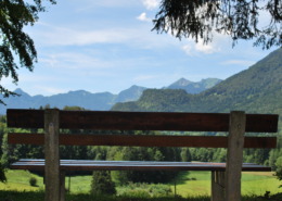 https://www.achental.com/en/storage/sites/10/2024/11/51266_Bank_mit_Aussicht_-_Minaruh-scaled.jpg
1714
2560
admin
https://www.achental.com/wp-content/uploads/2022/07/achental-logo-weiss-horizontal-RGB@2x.png
admin2024-10-01 17:50:352024-11-11 11:58:07River and moor hike through the Achental
https://www.achental.com/en/storage/sites/10/2024/11/51266_Bank_mit_Aussicht_-_Minaruh-scaled.jpg
1714
2560
admin
https://www.achental.com/wp-content/uploads/2022/07/achental-logo-weiss-horizontal-RGB@2x.png
admin2024-10-01 17:50:352024-11-11 11:58:07River and moor hike through the Achental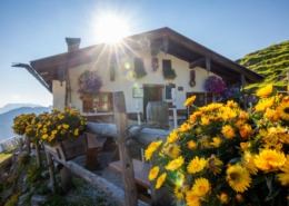 https://www.achental.com/en/storage/sites/10/2024/11/Te2tS4q2ZNk5iEXddzTbag4xoStiEYcopEfwl9o0-scaled.jpg
1707
2560
admin
https://www.achental.com/wp-content/uploads/2022/07/achental-logo-weiss-horizontal-RGB@2x.png
admin2024-10-01 17:50:342024-11-11 11:51:38Almwanderung zur Rechenberg-Alm
https://www.achental.com/en/storage/sites/10/2024/11/Te2tS4q2ZNk5iEXddzTbag4xoStiEYcopEfwl9o0-scaled.jpg
1707
2560
admin
https://www.achental.com/wp-content/uploads/2022/07/achental-logo-weiss-horizontal-RGB@2x.png
admin2024-10-01 17:50:342024-11-11 11:51:38Almwanderung zur Rechenberg-Alm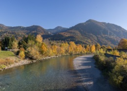 https://www.achental.com/en/storage/sites/10/2024/11/EH3CPTXurhRqZOwEUt1orWVrTFXkfhD2LU1KWGzY-scaled.jpg
1708
2560
admin
https://www.achental.com/wp-content/uploads/2022/07/achental-logo-weiss-horizontal-RGB@2x.png
admin2024-10-01 17:50:332024-11-11 12:11:39Circular tour to Marquartstein castle and river Tiroler Ache dam
https://www.achental.com/en/storage/sites/10/2024/11/EH3CPTXurhRqZOwEUt1orWVrTFXkfhD2LU1KWGzY-scaled.jpg
1708
2560
admin
https://www.achental.com/wp-content/uploads/2022/07/achental-logo-weiss-horizontal-RGB@2x.png
admin2024-10-01 17:50:332024-11-11 12:11:39Circular tour to Marquartstein castle and river Tiroler Ache dam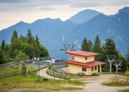 https://www.achental.com/en/storage/sites/10/2024/11/N2bNvLXAlAVqBVUmhM8WBwzY1qUKdpLbN0RQxYkn-scaled.jpg
1707
2560
admin
https://www.achental.com/wp-content/uploads/2022/07/achental-logo-weiss-horizontal-RGB@2x.png
admin2024-10-01 17:50:322024-11-11 12:12:18Circular trail Zeppelinhöhe
https://www.achental.com/en/storage/sites/10/2024/11/N2bNvLXAlAVqBVUmhM8WBwzY1qUKdpLbN0RQxYkn-scaled.jpg
1707
2560
admin
https://www.achental.com/wp-content/uploads/2022/07/achental-logo-weiss-horizontal-RGB@2x.png
admin2024-10-01 17:50:322024-11-11 12:12:18Circular trail Zeppelinhöhe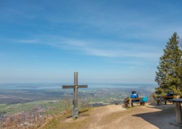 https://www.achental.com/wp-content/uploads/2022/07/achental-logo-weiss-horizontal-RGB@2x.png
0
0
admin
https://www.achental.com/wp-content/uploads/2022/07/achental-logo-weiss-horizontal-RGB@2x.png
admin2024-10-01 17:50:312024-11-11 12:11:13Rundweg Schnappenwinkl – Staudach
https://www.achental.com/wp-content/uploads/2022/07/achental-logo-weiss-horizontal-RGB@2x.png
0
0
admin
https://www.achental.com/wp-content/uploads/2022/07/achental-logo-weiss-horizontal-RGB@2x.png
admin2024-10-01 17:50:312024-11-11 12:11:13Rundweg Schnappenwinkl – Staudach https://www.achental.com/en/storage/sites/10/2024/11/eF5RWwpHLyZRBXIEDfQQZANZgDDIFpK9upEuLTMb-scaled.jpg
1919
2560
admin
https://www.achental.com/wp-content/uploads/2022/07/achental-logo-weiss-horizontal-RGB@2x.png
admin2024-10-01 17:50:312024-11-11 12:10:05Around Marquartstein castle
https://www.achental.com/en/storage/sites/10/2024/11/eF5RWwpHLyZRBXIEDfQQZANZgDDIFpK9upEuLTMb-scaled.jpg
1919
2560
admin
https://www.achental.com/wp-content/uploads/2022/07/achental-logo-weiss-horizontal-RGB@2x.png
admin2024-10-01 17:50:312024-11-11 12:10:05Around Marquartstein castle https://www.achental.com/en/storage/sites/10/2024/11/65WXYhJdPWmJTz4k5TUHiKCTixL2EgZmb2hAPpa1-scaled.jpg
1919
2560
admin
https://www.achental.com/wp-content/uploads/2022/07/achental-logo-weiss-horizontal-RGB@2x.png
admin2024-10-01 17:50:272024-11-11 12:10:47Circular tour via Minaruh and Streunthal
https://www.achental.com/en/storage/sites/10/2024/11/65WXYhJdPWmJTz4k5TUHiKCTixL2EgZmb2hAPpa1-scaled.jpg
1919
2560
admin
https://www.achental.com/wp-content/uploads/2022/07/achental-logo-weiss-horizontal-RGB@2x.png
admin2024-10-01 17:50:272024-11-11 12:10:47Circular tour via Minaruh and Streunthal https://www.achental.com/en/storage/sites/10/2024/11/BB6c390WBwrPa41LKQngrCwHVl0PRm8DcXUWGi0u-scaled.jpg
1707
2560
admin
https://www.achental.com/wp-content/uploads/2022/07/achental-logo-weiss-horizontal-RGB@2x.png
admin2024-10-01 17:50:272024-11-11 12:24:38To Unterwössen along Tiroler Ache and Richard-Strauss Höhenweg )
https://www.achental.com/en/storage/sites/10/2024/11/VhHN4nXmW8xKONAeuQqQjojDTSMjF3WQttzza5NH-scaled.jpg
1707
2560
admin
https://www.achental.com/wp-content/uploads/2022/07/achental-logo-weiss-horizontal-RGB@2x.png
admin2024-10-01 17:50:272024-11-11 12:15:16Schnappenkirche
https://www.achental.com/en/storage/sites/10/2024/11/BB6c390WBwrPa41LKQngrCwHVl0PRm8DcXUWGi0u-scaled.jpg
1707
2560
admin
https://www.achental.com/wp-content/uploads/2022/07/achental-logo-weiss-horizontal-RGB@2x.png
admin2024-10-01 17:50:272024-11-11 12:24:38To Unterwössen along Tiroler Ache and Richard-Strauss Höhenweg )
https://www.achental.com/en/storage/sites/10/2024/11/VhHN4nXmW8xKONAeuQqQjojDTSMjF3WQttzza5NH-scaled.jpg
1707
2560
admin
https://www.achental.com/wp-content/uploads/2022/07/achental-logo-weiss-horizontal-RGB@2x.png
admin2024-10-01 17:50:272024-11-11 12:15:16Schnappenkirche
 Alm hike to Haidenholz-Alm