

Circular tour to Marquartstein castle and river Tiroler Ache dam
Short hike via Marquartstein Castle and Tiroler Ache

distance
duration
highest point
meters upwards
meters downwards
We start the hike in the Freiweidach district and head towards the Hochgern car park. It is a beautiful path that takes us along the edge of a meadow area on an almost flat stretch for about a kilometer towards Maquartstein. At the next signpost we turn left towards the Burgberg circular path and walk up a forest path through a sparse forest, slightly uphill. The next sign leads us to the right along the circular path. Soon we come across houses and can see the castle in front of us. We can take the path leading up to the right past the church and castle entrance and then come back to Burgstrasse or alternatively continue straight on to Burgstrasse. On Burgstrasse we go downhill to the main road, turn right there and cross the historic bridge over the Ache. At the end of the bridge we find a staircase that we take down to the Achendammweg and we walk along this path to the next bridge, which we cross again. We follow the sign towards the Freiweidach circular path further and further and reach the starting point of our hike.
 https://www.achental.com/en/storage/sites/10/2025/11/89715__MG_6471.jpg
667
1000
admin
https://www.achental.com/wp-content/uploads/2022/07/achental-logo-weiss-horizontal-RGB@2x.png
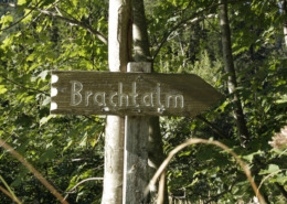
admin2025-09-23 10:17:352025-11-09 18:28:29SalzAlpenSteig – Brachtalm – Bergen
https://www.achental.com/en/storage/sites/10/2025/11/89715__MG_6471.jpg
667
1000
admin
https://www.achental.com/wp-content/uploads/2022/07/achental-logo-weiss-horizontal-RGB@2x.png
admin2025-09-23 10:17:352025-11-09 18:28:29SalzAlpenSteig – Brachtalm – Bergen https://www.achental.com/en/storage/sites/10/2025/11/9VruSXPV8ePSxZlnGpViGMZqYnWT2WmVj6N21gVK.webp
768
576
admin
https://www.achental.com/wp-content/uploads/2022/07/achental-logo-weiss-horizontal-RGB@2x.png
admin2025-08-11 01:05:512025-11-09 18:09:55Feldlahnalm tour
https://www.achental.com/en/storage/sites/10/2025/11/9VruSXPV8ePSxZlnGpViGMZqYnWT2WmVj6N21gVK.webp
768
576
admin
https://www.achental.com/wp-content/uploads/2022/07/achental-logo-weiss-horizontal-RGB@2x.png
admin2025-08-11 01:05:512025-11-09 18:09:55Feldlahnalm tour https://www.achental.com/en/storage/sites/10/2025/11/dnnXUqmOoT9qsZJ2w9KjLhaU9rm1fN1Pzba35MkA.jpg
1500
1000
admin
https://www.achental.com/wp-content/uploads/2022/07/achental-logo-weiss-horizontal-RGB@2x.png
admin2025-06-30 01:04:062025-11-09 18:19:21Kneipp circular tour
https://www.achental.com/en/storage/sites/10/2025/11/dnnXUqmOoT9qsZJ2w9KjLhaU9rm1fN1Pzba35MkA.jpg
1500
1000
admin
https://www.achental.com/wp-content/uploads/2022/07/achental-logo-weiss-horizontal-RGB@2x.png
admin2025-06-30 01:04:062025-11-09 18:19:21Kneipp circular tour https://www.achental.com/en/storage/sites/10/2025/11/51253_DSC00673_1920x1278.jpg
1278
1920
admin
https://www.achental.com/wp-content/uploads/2022/07/achental-logo-weiss-horizontal-RGB@2x.png
admin2025-04-30 09:21:342025-11-09 18:26:42Circular tour Grassauer Almen
https://www.achental.com/en/storage/sites/10/2025/11/51253_DSC00673_1920x1278.jpg
1278
1920
admin
https://www.achental.com/wp-content/uploads/2022/07/achental-logo-weiss-horizontal-RGB@2x.png
admin2025-04-30 09:21:342025-11-09 18:26:42Circular tour Grassauer Almen https://www.achental.com/en/storage/sites/10/2025/11/OqqtL2ddEOAljbylKsbGYuTNgwTs5VV03aCmQVk7.jpg
1707
2560
admin
https://www.achental.com/wp-content/uploads/2022/07/achental-logo-weiss-horizontal-RGB@2x.png
admin2025-04-24 01:08:072025-11-09 18:29:46Schmugglerweg to Kössen
https://www.achental.com/en/storage/sites/10/2025/11/OqqtL2ddEOAljbylKsbGYuTNgwTs5VV03aCmQVk7.jpg
1707
2560
admin
https://www.achental.com/wp-content/uploads/2022/07/achental-logo-weiss-horizontal-RGB@2x.png
admin2025-04-24 01:08:072025-11-09 18:29:46Schmugglerweg to Kössen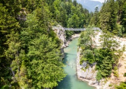 https://www.achental.com/en/storage/sites/10/2025/11/DBEUmwDZxqIa552KGtY7FRaBDy2zuyT3CSJVxLhF.jpg
1705
2560
admin
https://www.achental.com/wp-content/uploads/2022/07/achental-logo-weiss-horizontal-RGB@2x.png
admin2025-04-24 01:08:062025-11-09 18:30:25Schmugglerweg to Klobenstein
https://www.achental.com/en/storage/sites/10/2025/11/DBEUmwDZxqIa552KGtY7FRaBDy2zuyT3CSJVxLhF.jpg
1705
2560
admin
https://www.achental.com/wp-content/uploads/2022/07/achental-logo-weiss-horizontal-RGB@2x.png
admin2025-04-24 01:08:062025-11-09 18:30:25Schmugglerweg to Klobenstein https://www.achental.com/en/storage/sites/10/2025/11/sI0JyHhoSTI8r8TCYiee1ydZojiMieRrirnifIF6.jpg
1707
2560
admin
https://www.achental.com/wp-content/uploads/2022/07/achental-logo-weiss-horizontal-RGB@2x.png
admin2025-04-14 01:03:572025-11-09 18:05:06Auf historischen Pfaden
https://www.achental.com/en/storage/sites/10/2025/11/sI0JyHhoSTI8r8TCYiee1ydZojiMieRrirnifIF6.jpg
1707
2560
admin
https://www.achental.com/wp-content/uploads/2022/07/achental-logo-weiss-horizontal-RGB@2x.png
admin2025-04-14 01:03:572025-11-09 18:05:06Auf historischen Pfaden https://www.achental.com/en/storage/sites/10/2025/11/gzzxtE26tAeHfOmQ2Py2gP7DoMAzPHJDquWDsptw.jpg
1707
2560
admin
https://www.achental.com/wp-content/uploads/2022/07/achental-logo-weiss-horizontal-RGB@2x.png
admin2025-04-09 01:11:092025-11-09 18:43:33Schnappenberg – Schnappenkirche
https://www.achental.com/en/storage/sites/10/2025/11/gzzxtE26tAeHfOmQ2Py2gP7DoMAzPHJDquWDsptw.jpg
1707
2560
admin
https://www.achental.com/wp-content/uploads/2022/07/achental-logo-weiss-horizontal-RGB@2x.png
admin2025-04-09 01:11:092025-11-09 18:43:33Schnappenberg – Schnappenkirche https://www.achental.com/en/storage/sites/10/2025/11/byrz9Rdu4oAN0l849tnGJuWZPJQwfDPf8187HMNO.jpg
1707
2560
admin
https://www.achental.com/wp-content/uploads/2022/07/achental-logo-weiss-horizontal-RGB@2x.png
admin2025-04-09 01:11:092025-11-09 18:33:50Circular hike: Staudacheralm – Schnappenkirche
https://www.achental.com/en/storage/sites/10/2025/11/byrz9Rdu4oAN0l849tnGJuWZPJQwfDPf8187HMNO.jpg
1707
2560
admin
https://www.achental.com/wp-content/uploads/2022/07/achental-logo-weiss-horizontal-RGB@2x.png
admin2025-04-09 01:11:092025-11-09 18:33:50Circular hike: Staudacheralm – Schnappenkirche https://www.achental.com/en/storage/sites/10/2025/11/UkMX7jlNtUgz7DUN7zw7n8VZWRoafD2XjJtGyatW.jpg
1919
2560
admin
https://www.achental.com/wp-content/uploads/2022/07/achental-logo-weiss-horizontal-RGB@2x.png
admin2025-02-24 01:06:162025-11-09 18:14:11Valley circular trail
https://www.achental.com/en/storage/sites/10/2025/11/UkMX7jlNtUgz7DUN7zw7n8VZWRoafD2XjJtGyatW.jpg
1919
2560
admin
https://www.achental.com/wp-content/uploads/2022/07/achental-logo-weiss-horizontal-RGB@2x.png
admin2025-02-24 01:06:162025-11-09 18:14:11Valley circular trail https://www.achental.com/wp-content/uploads/2022/07/achental-logo-weiss-horizontal-RGB@2x.png
0
0
admin
https://www.achental.com/wp-content/uploads/2022/07/achental-logo-weiss-horizontal-RGB@2x.png
admin2025-01-01 01:04:262025-11-09 18:37:56Lake Taubensee via Luftboden- and Kroatensteig
https://www.achental.com/wp-content/uploads/2022/07/achental-logo-weiss-horizontal-RGB@2x.png
0
0
admin
https://www.achental.com/wp-content/uploads/2022/07/achental-logo-weiss-horizontal-RGB@2x.png
admin2025-01-01 01:04:232025-11-09 18:25:52Rundweg Schnappenwinkl – Staudach
https://www.achental.com/wp-content/uploads/2022/07/achental-logo-weiss-horizontal-RGB@2x.png
0
0
admin
https://www.achental.com/wp-content/uploads/2022/07/achental-logo-weiss-horizontal-RGB@2x.png
admin2025-01-01 01:04:222025-11-09 18:10:44River and moor hike through the Achental
https://www.achental.com/wp-content/uploads/2022/07/achental-logo-weiss-horizontal-RGB@2x.png
0
0
admin
https://www.achental.com/wp-content/uploads/2022/07/achental-logo-weiss-horizontal-RGB@2x.png
admin2025-01-01 01:04:262025-11-09 18:37:56Lake Taubensee via Luftboden- and Kroatensteig
https://www.achental.com/wp-content/uploads/2022/07/achental-logo-weiss-horizontal-RGB@2x.png
0
0
admin
https://www.achental.com/wp-content/uploads/2022/07/achental-logo-weiss-horizontal-RGB@2x.png
admin2025-01-01 01:04:232025-11-09 18:25:52Rundweg Schnappenwinkl – Staudach
https://www.achental.com/wp-content/uploads/2022/07/achental-logo-weiss-horizontal-RGB@2x.png
0
0
admin
https://www.achental.com/wp-content/uploads/2022/07/achental-logo-weiss-horizontal-RGB@2x.png
admin2025-01-01 01:04:222025-11-09 18:10:44River and moor hike through the Achental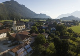 https://www.achental.com/en/storage/sites/10/2025/11/VVT8YD8z5ZEAzoiXkshUne9HdSbxdwHaAkTvV3bW.jpg
1919
2560
admin
https://www.achental.com/wp-content/uploads/2022/07/achental-logo-weiss-horizontal-RGB@2x.png
admin2025-01-01 01:04:212025-11-09 18:13:31Grießelberg-Rundweg
https://www.achental.com/en/storage/sites/10/2025/11/VVT8YD8z5ZEAzoiXkshUne9HdSbxdwHaAkTvV3bW.jpg
1919
2560
admin
https://www.achental.com/wp-content/uploads/2022/07/achental-logo-weiss-horizontal-RGB@2x.png
admin2025-01-01 01:04:212025-11-09 18:13:31Grießelberg-Rundweg https://www.achental.com/en/storage/sites/10/2025/11/89256_DSC00025.jpg
1536
2048
admin
https://www.achental.com/wp-content/uploads/2022/07/achental-logo-weiss-horizontal-RGB@2x.png
admin2025-01-01 01:04:192025-11-09 18:25:36Circular hike Hinterwössen
https://www.achental.com/en/storage/sites/10/2025/11/89256_DSC00025.jpg
1536
2048
admin
https://www.achental.com/wp-content/uploads/2022/07/achental-logo-weiss-horizontal-RGB@2x.png
admin2025-01-01 01:04:192025-11-09 18:25:36Circular hike Hinterwössen https://www.achental.com/en/storage/sites/10/2025/11/oVwKyuBPBxd4hb8dx2dB9cYkwxVcsjkJrcGgNKx1.jpg
543
768
admin
https://www.achental.com/wp-content/uploads/2022/07/achental-logo-weiss-horizontal-RGB@2x.png
admin2025-01-01 01:04:182025-11-09 18:11:40Geigelstein parking lot to Breitenstein via Karl – to Walchsee
https://www.achental.com/en/storage/sites/10/2025/11/oVwKyuBPBxd4hb8dx2dB9cYkwxVcsjkJrcGgNKx1.jpg
543
768
admin
https://www.achental.com/wp-content/uploads/2022/07/achental-logo-weiss-horizontal-RGB@2x.png
admin2025-01-01 01:04:182025-11-09 18:11:40Geigelstein parking lot to Breitenstein via Karl – to Walchsee https://www.achental.com/en/storage/sites/10/2025/11/wMi70NWgXiYlIFKkdOOpZl1UsbdCQKVH0V6cl5Ni.jpg
1707
2560
admin
https://www.achental.com/wp-content/uploads/2022/07/achental-logo-weiss-horizontal-RGB@2x.png
admin2024-12-30 01:04:102025-11-09 18:06:26Bergwalderlebnisweg Staffen with Hochplattenbahn cable car
https://www.achental.com/en/storage/sites/10/2025/11/wMi70NWgXiYlIFKkdOOpZl1UsbdCQKVH0V6cl5Ni.jpg
1707
2560
admin
https://www.achental.com/wp-content/uploads/2022/07/achental-logo-weiss-horizontal-RGB@2x.png
admin2024-12-30 01:04:102025-11-09 18:06:26Bergwalderlebnisweg Staffen with Hochplattenbahn cable car https://www.achental.com/en/storage/sites/10/2025/11/KKX9UDoPV12aMw9wvyEJ367aiX6VkZbBz3SUeNbQ.jpg
1707
2560
admin
https://www.achental.com/wp-content/uploads/2022/07/achental-logo-weiss-horizontal-RGB@2x.png
admin2024-12-30 01:04:092025-11-09 18:40:12Via Chiemhauseralm to church Streichenkirche
https://www.achental.com/en/storage/sites/10/2025/11/KKX9UDoPV12aMw9wvyEJ367aiX6VkZbBz3SUeNbQ.jpg
1707
2560
admin
https://www.achental.com/wp-content/uploads/2022/07/achental-logo-weiss-horizontal-RGB@2x.png
admin2024-12-30 01:04:092025-11-09 18:40:12Via Chiemhauseralm to church Streichenkirche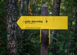 https://www.achental.com/en/storage/sites/10/2025/11/XQIxdrBep4hkkHo5ZkqtPoAaOrd6Xeszaw9QHE3g.jpeg
1080
1616
admin
https://www.achental.com/wp-content/uploads/2022/07/achental-logo-weiss-horizontal-RGB@2x.png
admin2024-12-30 01:04:092025-11-09 18:13:44Long Moorland Path
https://www.achental.com/en/storage/sites/10/2025/11/65WXYhJdPWmJTz4k5TUHiKCTixL2EgZmb2hAPpa1.jpg
1919
2560
admin
https://www.achental.com/wp-content/uploads/2022/07/achental-logo-weiss-horizontal-RGB@2x.png
admin2024-12-30 01:04:082025-11-09 18:25:16Circular tour via Minaruh and Streunthal
https://www.achental.com/en/storage/sites/10/2025/11/XQIxdrBep4hkkHo5ZkqtPoAaOrd6Xeszaw9QHE3g.jpeg
1080
1616
admin
https://www.achental.com/wp-content/uploads/2022/07/achental-logo-weiss-horizontal-RGB@2x.png
admin2024-12-30 01:04:092025-11-09 18:13:44Long Moorland Path
https://www.achental.com/en/storage/sites/10/2025/11/65WXYhJdPWmJTz4k5TUHiKCTixL2EgZmb2hAPpa1.jpg
1919
2560
admin
https://www.achental.com/wp-content/uploads/2022/07/achental-logo-weiss-horizontal-RGB@2x.png
admin2024-12-30 01:04:082025-11-09 18:25:16Circular tour via Minaruh and Streunthal

 Hike to Staudacher Alm