

Gscheuerwand
Beautiful circular tour with interesting views and the experience of watching the planes take off and land at the glider airfield.

distance
duration
highest point
meters upwards
meters downwards
Balsberg car park – Balsberg – Gscheuerwand – Achberg – Gliding airfield – Balsberg car park. From the car park, take path no. 91 towards Balsberg and Chiemseeblick. At the following junctions, always keep left on path no. 91. Shortly before you reach the Chiemseeblick, a path (path no. 94) branches off to the left to the Gscheuerwand. This section of the path is the most difficult of the hike. You need to be sure-footed here. Once you reach the Gscheuerwand, you can enjoy a panoramic view deep into the Achental. Continue on path no. 94, which meanders slowly down to Achberg. Once you arrive in Achberg, take path no. 15, which takes you right along the Tiroler Ache to the gliding airfield. At the end of the gliding airfield, turn right and you will soon be back at your starting point. Watch the gliders take off and land at the gliding airfield. Refreshments: Flieger Alm at the gliding airfield (please note the opening times)
 https://www.achental.com/en/storage/sites/10/2024/11/57445_BreitensteinGeigelsteinWiese.jpg
768
1024
admin
https://www.achental.com/wp-content/uploads/2022/07/achental-logo-weiss-horizontal-RGB@2x.png
admin2024-10-28 11:30:342024-11-11 11:55:27Breitenstein – summit tour
https://www.achental.com/en/storage/sites/10/2024/11/57445_BreitensteinGeigelsteinWiese.jpg
768
1024
admin
https://www.achental.com/wp-content/uploads/2022/07/achental-logo-weiss-horizontal-RGB@2x.png
admin2024-10-28 11:30:342024-11-11 11:55:27Breitenstein – summit tour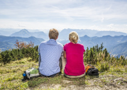 https://www.achental.com/en/storage/sites/10/2024/11/51254_Hochplatte_Aussicht_geniessen-scaled.jpg
1707
2560
admin
https://www.achental.com/wp-content/uploads/2022/07/achental-logo-weiss-horizontal-RGB@2x.png
admin2024-10-25 15:44:542024-11-11 11:59:20Summit hike to Hochplatte
https://www.achental.com/en/storage/sites/10/2024/11/51254_Hochplatte_Aussicht_geniessen-scaled.jpg
1707
2560
admin
https://www.achental.com/wp-content/uploads/2022/07/achental-logo-weiss-horizontal-RGB@2x.png
admin2024-10-25 15:44:542024-11-11 11:59:20Summit hike to Hochplatte https://www.achental.com/en/storage/sites/10/2024/11/51262__MG_8215_1920x1280.jpg
1280
1920
admin
https://www.achental.com/wp-content/uploads/2022/07/achental-logo-weiss-horizontal-RGB@2x.png
admin2024-10-25 15:44:222024-11-11 12:02:44Hochplatte – summit hike
https://www.achental.com/en/storage/sites/10/2024/11/51262__MG_8215_1920x1280.jpg
1280
1920
admin
https://www.achental.com/wp-content/uploads/2022/07/achental-logo-weiss-horizontal-RGB@2x.png
admin2024-10-25 15:44:222024-11-11 12:02:44Hochplatte – summit hike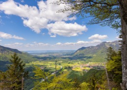 https://www.achental.com/en/storage/sites/10/2024/11/KRxCdIj4WAspwy6f5LsEbx0Xj4GlO4ttQkcsWkbm-scaled.jpg
1707
2560
admin
https://www.achental.com/wp-content/uploads/2022/07/achental-logo-weiss-horizontal-RGB@2x.png
admin2024-10-01 17:50:262024-11-11 12:01:25Gscheuerwand from Schleching
https://www.achental.com/en/storage/sites/10/2024/11/KRxCdIj4WAspwy6f5LsEbx0Xj4GlO4ttQkcsWkbm-scaled.jpg
1707
2560
admin
https://www.achental.com/wp-content/uploads/2022/07/achental-logo-weiss-horizontal-RGB@2x.png
admin2024-10-01 17:50:262024-11-11 12:01:25Gscheuerwand from Schleching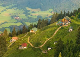 https://www.achental.com/en/storage/sites/10/2024/11/PPjkTKoxLcPu19ZQBH0kmhtH9tsMe1cgfRhNlBxL-scaled.jpg
1440
2560
admin
https://www.achental.com/wp-content/uploads/2022/07/achental-logo-weiss-horizontal-RGB@2x.png
admin2024-10-01 17:50:262024-11-11 12:02:27Hochgern summit via Staudacheralm and Hochgernhaus
https://www.achental.com/en/storage/sites/10/2024/11/PPjkTKoxLcPu19ZQBH0kmhtH9tsMe1cgfRhNlBxL-scaled.jpg
1440
2560
admin
https://www.achental.com/wp-content/uploads/2022/07/achental-logo-weiss-horizontal-RGB@2x.png
admin2024-10-01 17:50:262024-11-11 12:02:27Hochgern summit via Staudacheralm and Hochgernhaus https://www.achental.com/en/storage/sites/10/2024/11/4qBu16v9DKR0ZQK8JquINYgLZ2ZSINVDWCanXkGJ.jpg
300
444
admin
https://www.achental.com/wp-content/uploads/2022/07/achental-logo-weiss-horizontal-RGB@2x.png
admin2024-10-01 17:50:252024-11-11 11:59:01Geigelstein parking lot – Grießelberg – Rudersburg – Wetterfahne – Touristinfo Kössen
https://www.achental.com/en/storage/sites/10/2024/11/4qBu16v9DKR0ZQK8JquINYgLZ2ZSINVDWCanXkGJ.jpg
300
444
admin
https://www.achental.com/wp-content/uploads/2022/07/achental-logo-weiss-horizontal-RGB@2x.png
admin2024-10-01 17:50:252024-11-11 11:59:01Geigelstein parking lot – Grießelberg – Rudersburg – Wetterfahne – Touristinfo Kössen https://www.achental.com/en/storage/sites/10/2024/11/6cc0RM2ZGz9lWe868wHBXt4W3WEGITaKbqVRAty1-scaled.jpg
1707
2560
admin
https://www.achental.com/wp-content/uploads/2022/07/achental-logo-weiss-horizontal-RGB@2x.png
admin2024-10-01 17:50:252024-11-11 11:59:13Geigelstein parking lot – Priener Hütte – Karkopf – Walchsee
https://www.achental.com/en/storage/sites/10/2024/11/6cc0RM2ZGz9lWe868wHBXt4W3WEGITaKbqVRAty1-scaled.jpg
1707
2560
admin
https://www.achental.com/wp-content/uploads/2022/07/achental-logo-weiss-horizontal-RGB@2x.png
admin2024-10-01 17:50:252024-11-11 11:59:13Geigelstein parking lot – Priener Hütte – Karkopf – Walchsee https://www.achental.com/en/storage/sites/10/2024/11/133020_Kaisergebirge__Eisele_Hein_56-scaled.jpg
1704
2560
admin
https://www.achental.com/wp-content/uploads/2022/07/achental-logo-weiss-horizontal-RGB@2x.png
admin2024-10-01 17:50:122024-11-11 12:09:53Rudersburg – summit tour from Geigelstein parking lot
https://www.achental.com/en/storage/sites/10/2024/11/133020_Kaisergebirge__Eisele_Hein_56-scaled.jpg
1704
2560
admin
https://www.achental.com/wp-content/uploads/2022/07/achental-logo-weiss-horizontal-RGB@2x.png
admin2024-10-01 17:50:122024-11-11 12:09:53Rudersburg – summit tour from Geigelstein parking lot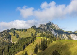 https://www.achental.com/en/storage/sites/10/2024/11/LQDJhUTAnQ8o9G5MOWfpAgcx8yqr56SPOoCNJKyA-scaled.jpg
1707
2560
admin
https://www.achental.com/wp-content/uploads/2022/07/achental-logo-weiss-horizontal-RGB@2x.png
admin2024-10-01 17:49:582024-11-11 12:03:50Kampenwand summit via Piesenhausener Hochalm
https://www.achental.com/en/storage/sites/10/2024/11/LQDJhUTAnQ8o9G5MOWfpAgcx8yqr56SPOoCNJKyA-scaled.jpg
1707
2560
admin
https://www.achental.com/wp-content/uploads/2022/07/achental-logo-weiss-horizontal-RGB@2x.png
admin2024-10-01 17:49:582024-11-11 12:03:50Kampenwand summit via Piesenhausener Hochalm https://www.achental.com/en/storage/sites/10/2024/11/N2bNvLXAlAVqBVUmhM8WBwzY1qUKdpLbN0RQxYkn-scaled.jpg
1707
2560
admin
https://www.achental.com/wp-content/uploads/2022/07/achental-logo-weiss-horizontal-RGB@2x.png
admin2024-10-01 17:49:582024-11-11 12:24:22Summit tour Hochplatte
https://www.achental.com/en/storage/sites/10/2024/11/N2bNvLXAlAVqBVUmhM8WBwzY1qUKdpLbN0RQxYkn-scaled.jpg
1707
2560
admin
https://www.achental.com/wp-content/uploads/2022/07/achental-logo-weiss-horizontal-RGB@2x.png
admin2024-10-01 17:49:582024-11-11 12:24:22Summit tour Hochplatte https://www.achental.com/en/storage/sites/10/2024/11/69LmF0xKH2axFoTmFLx34oGo2icqrJbbolmzZEEL-scaled.jpg
1707
2560
admin
https://www.achental.com/wp-content/uploads/2022/07/achental-logo-weiss-horizontal-RGB@2x.png
admin2024-10-01 17:49:582024-11-11 12:01:57Hochgern summit via Schnappenkirche, return via Hochgernhaus
https://www.achental.com/en/storage/sites/10/2024/11/69LmF0xKH2axFoTmFLx34oGo2icqrJbbolmzZEEL-scaled.jpg
1707
2560
admin
https://www.achental.com/wp-content/uploads/2022/07/achental-logo-weiss-horizontal-RGB@2x.png
admin2024-10-01 17:49:582024-11-11 12:01:57Hochgern summit via Schnappenkirche, return via Hochgernhaus https://www.achental.com/en/storage/sites/10/2024/11/9xXloyfRcXKO1NzvCAzG7yL1qfv4zLMXioPlNzEu-scaled.jpg
1707
2560
admin
https://www.achental.com/wp-content/uploads/2022/07/achental-logo-weiss-horizontal-RGB@2x.png
admin2024-10-01 17:49:542024-11-11 12:01:10Gscheuerwand
https://www.achental.com/en/storage/sites/10/2024/11/9xXloyfRcXKO1NzvCAzG7yL1qfv4zLMXioPlNzEu-scaled.jpg
1707
2560
admin
https://www.achental.com/wp-content/uploads/2022/07/achental-logo-weiss-horizontal-RGB@2x.png
admin2024-10-01 17:49:542024-11-11 12:01:10Gscheuerwand

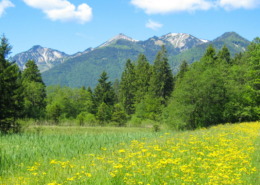
 Short Moorland Path

